![<p>Researcher collecting data from remote monitoring site [image courtesy: WAPDA] </p>](https://dialogue.earth/content/uploads/2016/11/Indus-basin-knowledge-platform2-300x169.jpg)
In an era of climate change, everyone is talking about water. At the just-concluded UN climate summit in Marrakech, Morocco, it was revealed that when governments of over 190 countries submitted their plans under the Paris Agreement, 93% of the projects aimed at adaptation to climate change impacts dealt with water.
See: The biggest climate change impact is on water
About 70% of the freshwater on earth is held in the ice caps and glaciers, according to the US Geological Survey. Glaciers are often referred to as the water towers of the world. They are the source of water in many rivers, be it in the Alps which feed European rivers or in the Himalayas, which feed the Indus, Ganga and Brahmaputra in South Asia.
Climate change has added to uncertainty of water flow in these lifelines of over a billion people, especially in the non-monsoon months when the meltwater from glaciers is crucial. This is especially true in the rivers of the Indus basin, which gets far less summer monsoon rain than the other two basins.
Add to this all the recent attention on water sharing arrangements in the Indus basin. Inevitably, the rising demand and use of the limited water resources of the basin is in focus.
See: World Bank drawn into Indus Waters Treaty dispute
In such a scenario, it is essential to go to the basics – the sources of water in these rivers. How much do we know about the glaciers and mountains, their behaviour and how climate change is impacting them? Are the glaciers retreating or surging? If so, what is the impact on water resources and on communities who are dependent on these waters? And, most importantly, do we know enough?
Climate change impact on Indus basin glaciers
Originating in northern slopes of the Kailash range in Tibet near Lake Mansarovar, the Indus is one of the longest rivers in the world. From China, it flows through India and then Pakistan. Important tributaries flow in from Afghanistan, making this a four-country transboundary basin.
![Map of Indus Basin [Source: Shabeh ul Hasson / Tobias Bolch]](/wp-content/uploads/2016/11/Map.png)
Understanding the snow cover and melt behaviour of glaciers is essential so that water resources can be managed optimally not just today but in future as well.
Glaciers are rivers of ice and snow. They flow and move in accordance with gravity, pressure and other factors. Scientists are creating models to simulate the behaviour of glaciers in order to estimate the flow levels and impacts in the quantity of water which might result in floods and droughts.
But the impact of climate change on glaciers is still not understood in its entirety. Researchers are simulating the response of climate systems to rising temperatures using Global Climate Models (GCM) and regional climate models, which provide information at a higher resolution, based on statistical and physically based downscaling methods driven by GCMs. However, these models have limitations as they are good at the continental and large regional scale but not very accurate at basin level, which would be needed to model the glaciers.
State of knowledge – past, present and future
How much do we know about glaciers in the Indus basin? “Not much,” says Shakeel Romshoo, a professor in the University of Kashmir, Srinagar. “There are about 23,000 square km covered by glaciers in the Himalayas. Most of these glaciers are in the Indus basin and only a few have been studied so far. Field-based observations and long-time series data are available for only 20-30 glaciers.”
University of Zurich’s Tobias Bolch echoes the concern. “We have good knowledge compared to five years ago and models which simulate the behaviour of glaciers at varying degrees of scale and accuracy. One needs to take into account multiple factors in conjunction, such as temperature, wind conditions, cloud cover, radiation and much more, to understand the changes in glaciers. But there are still lots that we don’t understand, like the Karakoram Anomaly.”
In the Karakoram range of the western Hindu Kush Himalayas, some glaciers are rapidly advancing when their neighbouring glaciers are retreating. This is known as the Karakoram Anomaly. During the surge, ice mass is rapidly moved from upper parts of the glaciers to the lower, keeping the total mass of ice more or less equal. This is different from most other glaciers in the Hindu Kush Himalayas, where the melting rate of the ice is higher than the rate at which ice is accumulating at the top of the glacier.
The anomaly continues to puzzle scientists. “We need to improve the models [that we currently have], and what we need is more sites across the basin where more detailed measurements can be taken,” says Bolch.
![Researchers collecting data from remote sites [images courtesy: University of Kashmir]](/wp-content/uploads/2016/11/Indus-basin-knowledge-platform0.jpg)
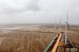
“The highest monitoring station in Pakistan is installed at a height of 4,750 metres above sea level in Khunjerab pass,” says Khan of GMRC. “We have about 20 stations installed in high altitude regions and our team ensures that they are visited at least once in a year. It is a challenging task.”
![Highest climate monitoring station in Pakistan at Khunjerab at 4,750 metres above sea level [image courtesy: WAPDA]](/wp-content/uploads/2016/11/Indus-basin-knowledge-platform3.jpg)
“There are several glaciers which are covered with debris. Field work is necessary to obtain important information as the debris significantly alters the melt processes. The combination of field and remote data would be the optimum in such cases,” says Bolch.
![Member of monitoring team standing in front of a Debris-covered Glacier [image courtesy: WAPDA]](/wp-content/uploads/2016/11/Indus-basin-knowledge-platform1.jpg)
Sharing knowledge
The other big challenge is to share the knowledge between the countries in the Indus basin. As Romshoo puts it, “Glaciers in different regions are behaving differently. It is important to establish networks and share information to get a holistic understanding of what is happening in the basin.”
With water-sharing pacts in the news, it is important to understand the availability of water in the Indus basin, which is directly related to the state of the glaciers. Rapid urbanisation and increasing demands on the limited water resources underscore the need for better understanding of the science, socio-economic and demographic changes taking place in the basin.
The Indus basin has the distinction of having one of the most successful water sharing treaties in the world – the 1960 Indus Waters Treaty (IWT) between India and Pakistan. The treaty has endured squabbles, arbitration and even wars between the two countries.
See: Indus Waters Treaty rides out latest crisis
See: Pakistan reacts quietly to Indian move on Indus Waters Treaty
See: India suspends Indus commissioners’ meetings
However, drafted over half a century ago with the scientific understanding that was available, the treaty does not take into account climate change and other pertinent issues of which there was no knowledge at the time. Future basin-wide planning, encompassing all four countries, would assist in tackling mounting challenges of climate change and growing demand for the resource as basin populations and economies grow.
Way forward – Indus Basin Knowledge Platform
Policymakers cannot wait for the science to be perfected. So it is essential for them to be aware of the current state of knowledge.
“It’s always good to maintain a healthy scepticism when it comes to climatology and hydrological models,” says Khan of GMRC. “You can never predict natural phenomenon and their complex interrelationships in totality. There is always a degree of uncertainty when complex processes are analysed through mathematical models. But one needs to make decisions in this context.”
Talking about new research tools, Khan says, “These tools do help us improve our understanding. When we make a proposal, say for constructing a dam, we take multiple parameters into account and build in a safety parameter which takes care of any future exigency. A better model helps us in narrowing the uncertainty and in turn, helps us save precious resources and effort.”
But most experts agree that an integrated way of looking at the basin and planning at that scale is still missing. Better data will help in producing better model and better analysis. More research and data collection needs to be done and knowledge needs to be shared to promote an improved understanding of the changes taking place in the basin.

This is where the Indus Basin Knowledge Platform recently developed by the International Water Management Institute aims to make a difference. Launched at this year’s World Water Week, the platform is a repository of the knowledge obtained from scientific research in the basin, from the sources to the Arabian Sea. By putting in one place the results of research activities in various countries and making it accessible to all, it fills a crucial gap in the region. The platform is updated regularly, and researchers can submit their own findings to supplement this effort.
Reiterating the need to understand the glaciers, rivers and climate change nexus, Romshoo says “It is all the more important when water is being shared between countries. Water can become a source of cooperation or a source of conflict between nations. Many times natural changes like sedimentation, or changes in the course of a river affect the flow and are mistakenly attributed to deliberate actions by the upstream member, potentially leading to discord.”
Considerable progress has been made in understanding current and future challenges in the basin, but there is still a long way to go in ensuring a more level playing field of access to knowledge. Tools such as Indus Basin Knowledge Platform are one way forward, reducing transaction costs to gaining understanding and supporting more informed basin management into the future