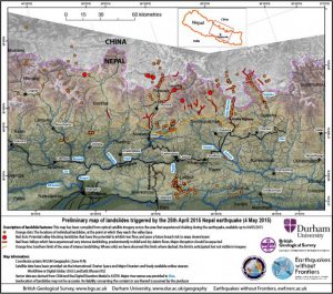

Nepal needs to urgently assess the risks from existing and potential landslides in earthquake affected areas before the monsoon rains come, say scientists who have produced a detailed map of landslide risks using satellite data.
The report released by scientists at the British Geological Survey, Durham University and University of East Anglia this week says: “The need to plan measures to mitigate landslide deaths and disruption in the forthcoming monsoon season must remain a priority. Many more damaging landslides may occur in the 2015 monsoon, likely to start in late June, than would be expected if a major earthquake had not occurred.”
The scientists identified at least six major landslides blocking valleys in areas hit by the 7.8 magnitude earthquake on 25 April. But the team says more major landslides may be found as more satellite imagery becomes available (large areas of the region are still obscured by cloud and dust).
The risks of landslides will “escalate significantly” as the monsoon rains begin, the report added. The monsoon that reaches Nepal in second week of June and withdraws in September brings almost 80% of the country’s total annual rainfall.
Fresh landslides will threaten already-affected areas and wash sediment downstream onto valley floors and floodplains.
Major landslides are limited to a zone that runs east-west almost parallel to the transition between the lesser and High Himalaya near the China-Nepal border. This zone includes parts of the most affected districts –Gorkha, Dhading, Nuwakot, Rasuwa, Sindhupalchwok, Dolakha, Ramechhap and Kavre, where most of the fatalities due to the earthquake occurred. Major roads to Tibet in the north and India in the south have also been blocked.
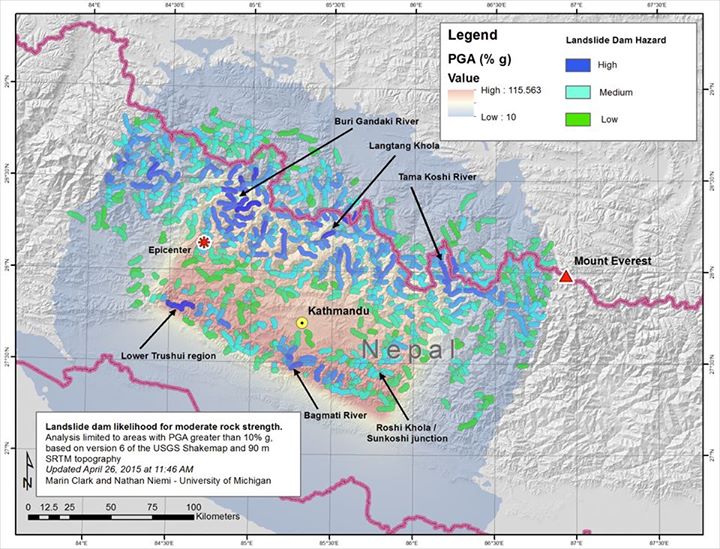
A team led by the University of Michigan geomorphologist Marin Clark has also identified tens of thousands of locations at risk of mudslides and landslides in the mountainous area along the Nepal-Tibet border, north of Kathmandu and west of Mount Everest.
According to satellite images, avalanches and landslides have blocked the upper reaches of Buri Gandhaki river in Gorkha district, the Trishuli river near Thansing and the Sunkoshi river near Sarsunkharka.
No local warning systems
Satellite images provided by the International Centre for Integrated Mountain Development (ICIMOD) on their website are consistent with Clark’s assessment.
But this information is not reaching local people. “The district administration has not informed us about the river blockages. People are more concerned about procuring plastic sheets right now,” Kapil Koirala, a resident of Dhulikhel, which lies on the Arniko highway to Tibet, told thethirdpole.net. People are scared about the floods and want to move to safer districts but they don’t know which places are safer, he said.
“The cloud cover has made it difficult for us to get accurate satellite pictures and travelling to the areas where landslides have occurred is not possible right now,” said Narendra Raj Khanal of ICIMOD. “I have asked for water discharge data and once I have this I will be in a better position to say how serious the river blockages could be,” he said.
In 2014 flash floods in Sindhupalchowk district on the Nepal-China border killed 156 people, after a massive landslide blocked the Sunkoshi River.