During the day-long rain spell on 16th July, Lahore’s famous Lakshmi Chowk received more than 250 millimetres of rainfall. To put things into perspective, the average rainfall for the whole month of July (mean from 1961-1990) for the city is 202 mm.
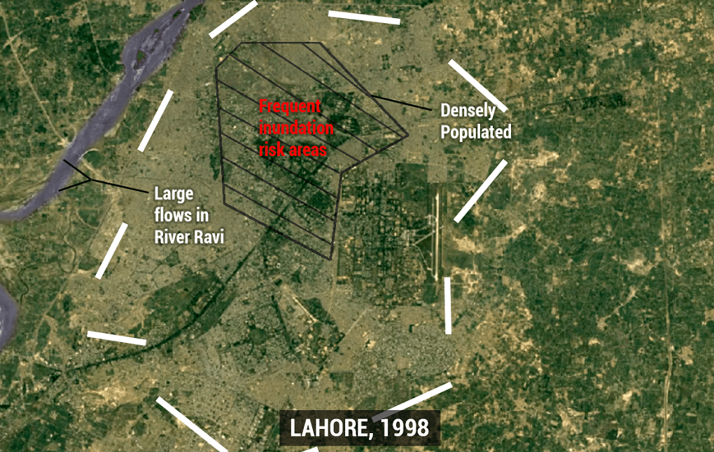
In 1996, Lahore received 496 mm of rain in 36 hours during a monsoon spell, breaking all records in recent memory. The Ravi, which at the time was unhindered on the Indian side, overflowed and most of Lahore flooded.
It was an anomaly that has not been repeated since as the water flows have massively declined in the last two decades. But the Ravi does not need to overflow to leave Lahore flooded.
A combination of above-average rainfalls and over-development has made the city regularly witness pluvial flooding (urban flooding caused by excess rainfall and slow drainage flows), for which no cure or mitigation has been devised.
Lahore, probably Pakistan’s most developed metropolis, has become critically vulnerable to pluvial flooding. Year after year (2015, 2018), the rain causes considerable infrastructural damage, while many citizens lose their lives due to related accidents.

As Lahore’s urban sprawl has grown, the city managers have largely failed to cater to its drainage needs. This simply means that, while housing societies, concrete boulevards, flyovers, underpasses, high-rises and signal-free corridors have popped up all over the city, green spaces and the urban tree canopy has had to bear the brunt of these developments. At the same time, Lahore’s drainage system capacity has also declined.
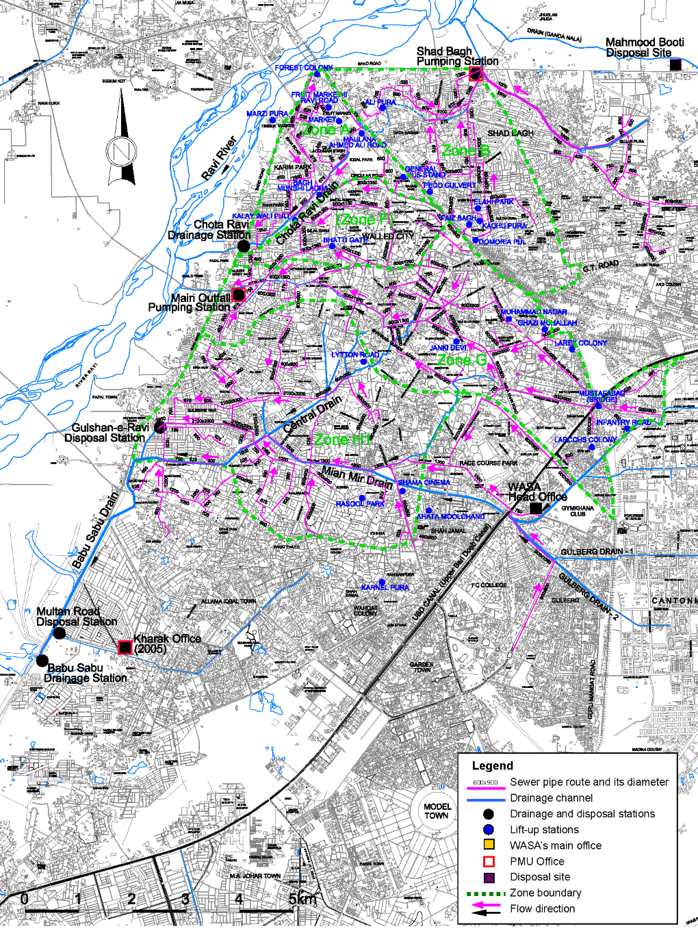
The city is served by eight main drains: Central, Lower Mall, Chota Ravi, Alfalah, Gulberg 1 and 2, Edward Road, Mian Mir and Gulshan-i-Ravi. 76 tributary drains are connected to them. Combined, they make up a lengthy network of 180 kilometres, with a theoretical carrying capacity of nearly 6,500 cusecs. But urbanisation and reduction of green spaces has increased the strain on these waterways.
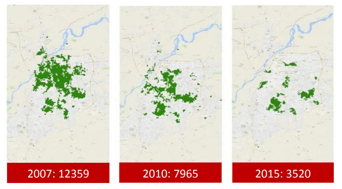
Lahore’s tree cover fell by 72% from 12,359 trees in 2007 to just 3,520 in 2015. The main drains are always vulnerable to siltation as the surface runoff deposits large amounts of sediment into them. A Japan International Cooperation Agency (JICA) study in 2004 revealed that nearly 400,000 cubic metres of sediment deposits had gathered in these drains, which were gradually removed by the Water and Sanitation Authority (WASA) with assistance from JICA.
The sediment deposits reduce the carrying capacity of the drains, making them less and less effective in times of heavy rainfalls. With reductions in green cover and water absorption into the soil, and increased surface runoff of sediment into the drains, Lahore can no longer deal with the monsoon.
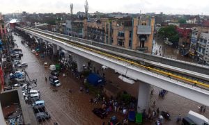
Just a few years after the WASA reclamation project, pluvial floods struck Lahore in 2007 and 2008. They wreaked havoc in the city’s northern quarters, which are also the oldest and most densely populated. Localities including Lakshmi Chowk, Bhatti Gate, Empress Road, Cooper Road and Chaburji were inundated, reminiscent of the 1996 episode.
These episodes have grown more frequent. While cumulative rainfall during monsoon has remained in the normal range, the intensity of single rainfall events has risen. Above-average single rainfalls occurred in Lahore in 2010, 2014, 2015 and 2018. Enough meteorological data is present to attribute these anomalies to the global climate crisis.
In a report published by the Pakistan Meteorological Department’s Global Change Impact Study Center, researchers have predicted that, with rising temperatures, rainfall events in Lahore during monsoon will become more and more extreme.
Monsoon winds are driven towards high-temperature inlands. The urban heat island effect generated due to Lahore’s accelerated development and urbanisation could become a cause of such extreme events. The urban heat island means that temperatures within the urban part of the district are higher than the peripheral and adjoining rural areas. The resulting differences can concentrate rain clouds over such hot spots.
Future-proofing Lahore requires serious changes in the city’s current urbanisation trajectory, as well as capacity building of critical agencies and departments. A master plan for Lahore’s sewerage and drainage systems is needed. But financial cuts — from having a budget of around PKR 18 billion (USD 112 million) for WASA in 2017 down to PKR 9 billion (USD 56 million) in 2019 — don’t help.
With the reasons for pluvial flooding well understood, city managers must prepare in advance. Sustainable urban development practices, climate-sensitive city planning, capacity building of WASA and creatively using Lahore’s geography can provide reasonable safety nets for people to survive through monsoon spells.
The Pakistan Meteorological Department had predicted a normal to above-normal monsoon for this region well in advance this year, but the government’s plan emerged only a few days ahead of the spell, and was one of disaster management rather than prevention.
In an era of highly developed climate models, the district government and WASA should prepare beforehand to prevent flooding. The preparations require a sizable mobilisation of government apparatus, and should follow a step-by-step strategy: rehabilitate, respond and reform.

Drains, both major and minor, also need to be lined with trees of various native species to create a buffer against outflows and reduce surface runoff.
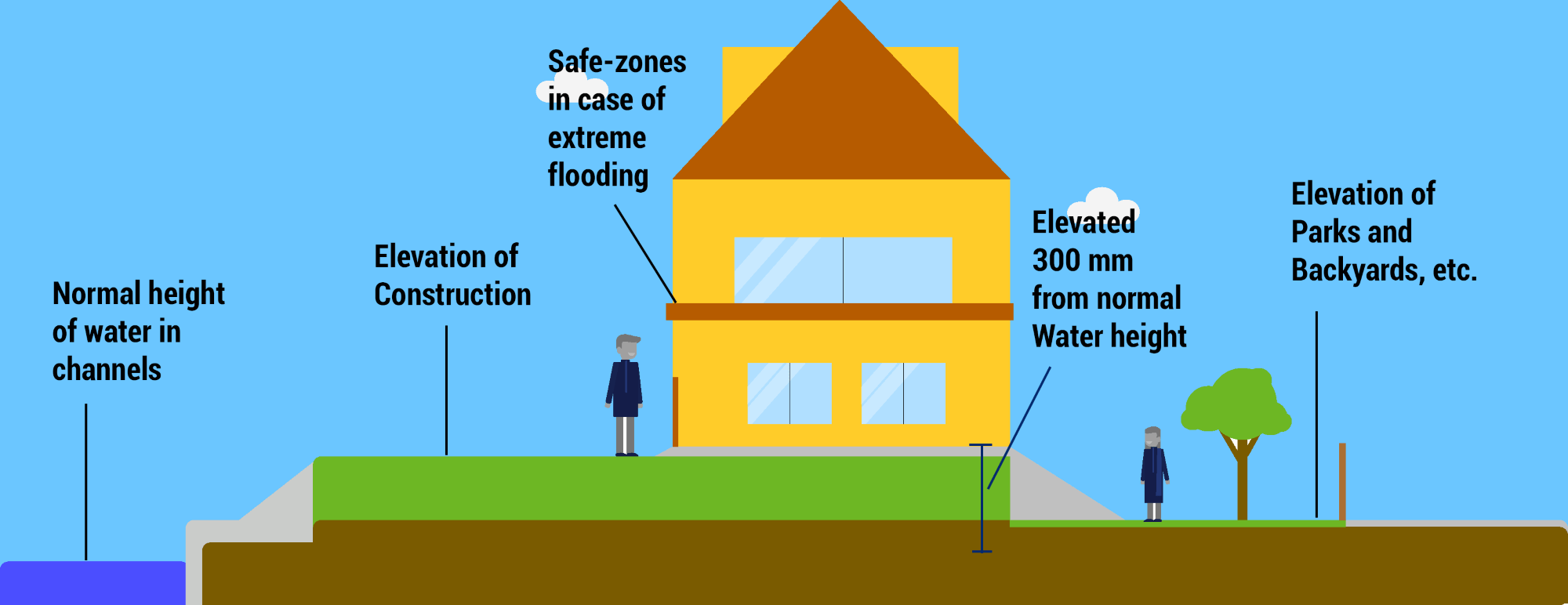
City planners have to rethink urban development as well. Pluvial flooding is not a developing world issue. Rotterdam, after suffering from numerous such episodes, is now dealing with this problem using what is dubbed as water squares. Parks and grounds, with abundant trees and at a lower elevation, allow for absorption of water, and act as temporary reservoirs during storms. An underground reservoir can both hold water during storms and allow it to percolate into the aquifer.
Urban housing can similarly be designed to prevent flooding of roads and houses, with the landscape formulated in a way to provide necessary safeguards.
These changes can prepare the city for the long-term impacts of the climate crisis, though these are likely not enough, and a thorough review of the city’s current development and growth trajectory is also required.
As another spell of rainfall looms over Lahore, it is the right time for citizens and planners to start preparing for this century.
This article was originally published in the Dawn, and has been republished with permission