The death toll and the financial loss in the mid-June flash floods and landslides in Uttarakhand are still being computed. Meanwhile India’s National Institute of Disaster Management (NIDM) has come up with a report that raises questions on the current pattern of human activities in this Himalayan region.
Prakash points out in his report that as a result of the cloudburst on June 15-16, the Alaknanda river and its tributary Mandakini “occupied their flood ways and started flowing along the old courses where human habitation had come up with passage of time (when the river had abandoned this course and shifted its path to the east side).” The Alaknanda is one of the main sources of the Ganga, India’s longest river and one of the major rivers of the world.
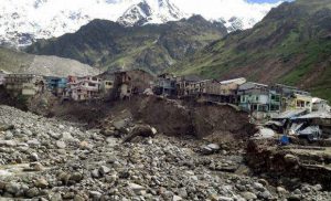
The Mandakini changed its course to the west “when the moraine dammed lake at Gandhi Sarovar breached,” Prakash says. “The sediment loaded river began eroding / dumping whatever came in its way. Most of hotels, shops and guest houses / lodges were located on this side and got washed (away) by the river water, killing many of the people who were present there.”
The expert points out that even in the narrow valleys of the Himalayas, the Alaknanda and Mandakini are rivers that keep changing their course. The reports says, “Due to morphological setting of the area, the river has high sinuosity and hence, high level of erosive capacity, especially when it is loaded with sediments (the erosive power of river with sediments is almost square of the erosive power without sediments).”
Referring to the reasons why the flash floods led to such destruction, the report says, “The area has been denuded to a great extent due to deforestation and tree cutting for road construction, building construction, mining, hydel projects etc. It has also resulted into increased surface flow and rise of river bed due to disposal of debris into the rivers.”
These disturbances have compounded the instability of the world’s highest and youngest mountain range. The report says, “Geologically, the rocks in this area are found highly deformed, degraded and dissected by structural discontinuities and drainages. Seismo-tectonically, the area is traversed by several lineaments, faults and thrusts, which are considered to be geodynamically active. The area had suffered an earthquake on March 29, 1999 (M-6.8) which caused loosening of rock masses, ground cracks and landslides etc., besides killing more than a hundred people due to collapse of buildings. Thus, the natural terrain conditions combined with climatic / weather conditions and haphazard human intervention made a conducive environment for such a hazardous process to take place in this valley.”
Prakash says, “The hazard turned into a major disaster when people along with their properties and infrastructure occupied such areas without adequate information, knowledge, awareness and preparedness against the potential disaster. As June is a month for pilgrimage by the Hindus and Sikhs, most of the people prefer to visit the temples at Kedarnath, Badrinath and Hemkund Sahib before the monsoon begins. A huge crowd was present in the valley as tourists, pilgrims and trekkers besides the local population, businessmen, tour / lodge / guest house operators etc.”
And most of the visitors, from the Indian plains, did not know what to do when the waters started rising. The report says, “These people could not understand what is likely to happen next. By the time, they realized the (gravity of the) event, they were already trapped into it and could not find ways to escape. Thus, a large number of people ran to safety on the uphill sides and many of them even tried to quickly cross the swollen fast flowing river that engulfed them as it appeared in furious mood with lot of big stones and sediments.”
Referring to what Prakash saw a week later on the road from Rishikesh to Chamoli, the report says, “The roads were found blotted with numerous landslides (both fresh and reactivated ones), cracks and subsidence throughout the highway… A huge amount of sand was found deposited at Srinagar that blocked the highway which was located close to the river… Similarly damages to roads, bridges and buildings were also seen on the upstream side up to Chamoli.”
The recommendations made in the report include:
- Development of necessary guidelines and action plans for tourist / pilgrimage places, hotels/lodges/guest houses etc., keeping in mind the concentration of people at such locations during the time of disasters
- Prepare a disaster risk assessment and reduction plan including immediate, short, medium and long term actions, that may be undertaken for integrating DRR (disaster risk reduction) with development in future
- The area may be studied from technical as well as socio-environmental point of view to propose suitable developmental activities and discourage improper constructions.
- Innovative ideas for amalgamation of state of art technology with the indigenous traditional knowledge and skills for effective community practice.
NIDM is an autonomous institution but under the aegis of India’s powerful home ministry. Environmentalists are hoping that its recommendations will lead to a more sustainable development path in Uttarakhand, and perhaps in more areas of the Himalayas.