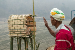
About a year ago, the Boon Rueang Wetland Forest Conservation Group began a survey of wildlife in the 483-hectare community forest in northern Thailand. “We have recorded some leopards, otters and other animals,” says Songpol Chanruang, chair of the group.
Though only around 130 kilometres long, the Ing River that feeds the Boon Rueang wetlands is the second most important habitat for the Eurasian otter in Thailand, according to the Living River Association, an NGO that promotes community-based conservation in the Mekong basin. The Eurasian otter – a species listed as globally Near Threatened by the International Union for Conservation of Nature – is known to occur at at least 10 locations along the banks of the Lower Ing River.
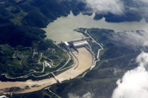
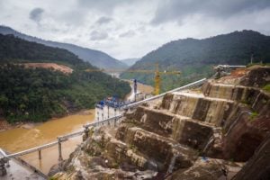
The Ing River is a tributary of the Mekong. The stretch where the Ing and other tributaries like it in northern Thailand flow into the Mekong is sandwiched between a huge number of dams. There are 11 hydropower dams upstream on China’s section of the Upper Mekong – known as the Lancang – and 11 more in various stages of planning and completion on the Lower Mekong in Laos and Cambodia, most with some level of Chinese involvement in development or construction. The effects of upstream dams on the ecology of downstream tributaries are largely unknown.

“The seasonal cycle has changed over the years, and this was noticed after dams were built… especially during the past 10 years,” Chanruang says. “The Mekong hardly floods into the Ing River, or if it floods it no longer lasts for a few months, but a week, or even just a few days.”
“We just hope [the otters] can adjust to the changing environment by using their wild instincts to find a safe place to breed and feed,” says Chanruang, stressing the need for more study and public engagement.
Changing Mekong floods
The Mekong floods during the wet season between June and October, filling the Ing and other tributaries. This soaks the wetland forests of Thailand’s north.
The natural flooding of the Mekong provides this region of Thailand with the water, fish and nutrients needed to support the Ing River forests and wetlands. The fish nursery this creates sustains both wildlife, such as otters, and communities downstream.
But in the past decade, a spate of dam projects on the Mekong mainstream have resulted in the flooding process becoming unnaturally intense and rapid.
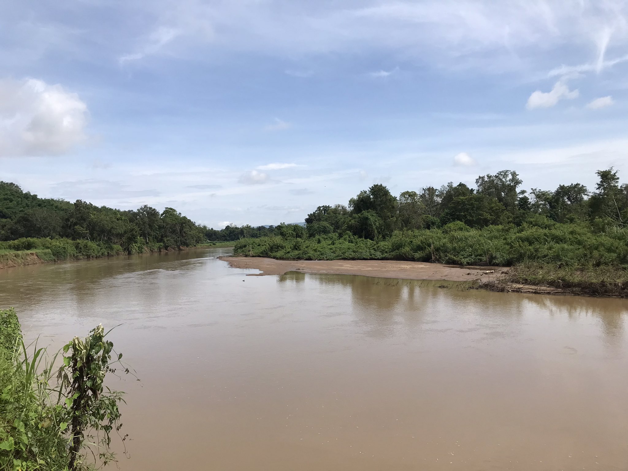
“The water now comes and goes quickly, not lingering in the forest like it did in the past,” says Chanruang, describing the seasonal floodwaters of the Ing River. “It’s clear that [water levels] have dropped significantly during the rainy season over the past few years. Its colour has also changed, from muddy water to clear.”
Clear and blueish water, which has been seen even on the Mekong mainstream in recent years, signals a lack of suspended sediment. This material and the nutrients it contains is essential to all life on the Mekong and its tributaries.
The northernmost monitoring station in the Lower Mekong Basin is at Chiang Saen district in Thailand, just upstream of the Ing River. Quantities of sediment recorded here have fallen from 85 million tonnes per year (MT/yr) in 2001 to just 10.8 MT/yr. Only 16% of the sediment that is deposited in the Lower Mekong basin now comes from China, compared with 55% historically.
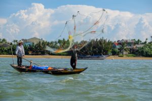
“There are about 26 wetland forests remaining in the Lower Ing which are managed by local communities,” says Teerapong Pomun of the Living River Association, adding that the knock-on effects of these unnatural water levels on local people include changing fish populations, falling incomes and riverbank erosion.
Though there is little data available on the overall biodiversity of the Ing, the State of the Basin Report 2018 from the Mekong River Commission (MRC) showed drops in fish catches along the river. In the nearby province of Luang Prabang in Laos, the catch rate for gillnets fell by 17% between 2008 and 2013.
More dams, more disrupted ecosystems along the Mekong
More dams are planned or are under construction. The proposed Pak Beng mainstream hydropower dam, a project in Laos funded by China Datang Corporation and the Laos government, will be built just 80 kilometres from the mouth of the Ing. Preliminary construction on the Luang Prabang dam, the next closest mainstream Mekong hydropower project, has reportedly already begun in Laos.

“Any [further] changes to the Mekong River will definitely affect the river’s tributaries and wetlands adjacent to it,” says Pianporn Deetes, communications director for Southeast Asia at the NGO International Rivers. She adds that the Mekong is a complex system in which different ecosystems are connected. “As the river is dammed upstream, the entire ecosystem is cut off and disrupted.”
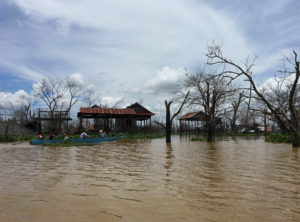
Throughout most of the 2021 wet season so far there have been drastic changes in water levels in the Lower Mekong Basin, due to a combination of low rainfall and upstream hydropower operations in China. Since July there have been dozens of hydropeaking events and severe drops of more than 50cm at a time, according to data from the Mekong Dam Monitor, a public online monitoring platform which measures climate issues using satellite imagery, GIS analysis and remote sensing.
Hydropower dams meet higher demands for energy during the day. At night, the turbines are turned off and the release of water is restricted, resulting in hydropeaking – the rapid raising and lowering of a river’s water levels. These create difficulties for fish navigating in the river and beach-nesting birds.
“Water levels and flows are supposed to be high [now], as high as 6 to 7 metres, but we can only see a few metres in this rainy season,” says Deetes. She adds that the villagers in Boon Rueang have been fighting to protect their forest: “They have been conserving it, creating conservation zones and such, but considering the scale of the problem, this would mean almost nothing.”
Low levels on the Ruak River impact wildlife on the Thailand border
Beyond the Ing and Boon Rueang, the Ruak River meanders through flat grasslands and agricultural areas, marking the border between Thailand and Myanmar until the Ruak meets the Mekong, and Laos, at the so-called ‘Golden Triangle’.
This year, as Thailand entered the heart of the wet season, multiple organisations and experts say upstream hydropower operations on the Mekong caused low levels on the Ruak, with sandbanks normally only visible in the dry season appearing in July – a preview to the unpredictable water levels of the 2021 wet season. (Experts in China dispute this connection.)
Just 500 metres north of where the Ruak meets the Mekong are the grasslands of the Golden Triangle Asian Elephant Foundation (GTAEF), which works with around 20 rescue elephants.
“The biggest ecological effect we have seen [since the largest dams came online] is the loss of breeding and spawning grounds for fish and wildfowl that have lost a sheltered [place], protected from predators and hunting, a place to raise their young or to grow,” says John Roberts of GTAEF. Roberts says that for his first 10 years in Thailand (2003-2013), the river flooded so predictably between June and October that the foundation planned its elephant management around the flooding, but this is no longer possible.
The fertile area where the Ruak meets the Mekong used to be home to a birds such as the grey-throated martin, a swallow species which nests in river banks and is now rarely seen in the area. Many bird species, such as the small pratincole, lay their eggs in the sandbanks along the Mekong and its tributaries, and are now facing losing their nests to unnatural flooding.
Exacerbating the threats posed to the wildlife of this region of Thailand by changes to the river, Roberts says, is the fact that areas of grassland habitat “up and down all our local tributaries have been cleared for monoculture agriculture, mainly corn, [which were] unviable previously due to the annual floods… The balance of the ecosystem will shift and different species will be supported.”
Need for cross-border cooperation on conservation
Due to both Covid-19 and unrest in Myanmar following the military coup, cross-border cooperation on conservation issues has become even more difficult in recent years. The main body for transboundary governance of the Mekong’s water resources is the Mekong River Commission, but it is purely advisory and cannot prevent the construction of new infrastructure projects.
“It still really depends on investors or developers [of dams] to address the problem and solve it,” says Deetes. “They need to understand the nature of the river, its system, and the impacts they can cause.”
Following years of transboundary negotiation and campaigning, recent developments have led to accurate and near-real-time data sharing from hydrological stations on the Mekong. Via the Lancang Mekong Cooperation (LMC) framework, China has been cooperating more closely with the MRC on water levels. However, effects on tributary rivers of an unnatural flood pulse are even less well known than on the mainstream. The largest dams on the Mekong mainstream are in China, and though river levels are reported via the LMC, China shares sparse operational dam data with those downstream.
“The fact is the dams are far away, but their impacts are here and real,” says Chanruang. “We are always concerned about them but we can never reach them and deal with them directly.”