
The International Centre for Integrated Mountain Development (ICIMOD) released the first comprehensive report on the Hindu Kush Himalayan (HKH) region, and it contains some very worrying news for the Indus basin. Titled HIMAP for the Hindu Kush Himalayan Monitoring and Assessment Programme, the report looked at 16 components of change in the HKH region, filling in a gap left by Intergovernmental Panel on Climate Change (IPCC) reports that had limited information from the region.
One of the areas of key concern was the cryosphere, or ice coverage, in the area, which is home to the most glaciers after the polar regions. According to the report 36% of the volume of these glaciers will be gone by 2100 if the world manages to keep warming below 1.5 degrees Celsius. If this temperature increase hits 2 degrees Celsius, 49% of the volume of these glaciers will be gone.
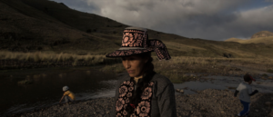
The retreat of these glaciers will have an immediate impact on the 240 million people that live in the mountains, many of whom are critically dependent on the water flow from snow and ice melt. Given that poverty rates in these regions is 33%, significantly higher than the overall 25% for the eight countries that border the region, this will be a disaster in itself. The more complex, and problematic, issues will be downstream to these regions, inhabited by 1.65 billion people, and one of the basins most impacted will be the Indus – that straddles China, India, Pakistan and Afghanistan.
One of the reasons is that the Indus River is the one most dependent on snowmelt and glacier melt contributing close to 80% of its water flow – compared to the Ganga and Brahmaputra, which are mostly dependent on rainfall runoff. As the glaciers retreat at a sharper pace, this basin will have more water flowing in, but in an increasingly unpredictable manner.
Tobias Bolch, from the University of Zurich’s geography department and one of the contributing lead authors of the chapter on the cryosphere in the HKH region said, “The Indus glaciers span a large region. In the Karakorum range there is a mass balance [the glaciers are gaining as much ice as they lose], but that is a mix of melting and rapid advance of some glaciers. This increases the risk of GLOFs (Glacier Lake Overflow Floods). In Lahaul Spiti (in India), on the other hand, you have rapid glacier retreat, and this destabilises the land from where the glaciers retreat.” He added that the cryosphere was not just the glaciers. The melting of permafrost – perennially frozen ground beneath the surface – as glaciers retreat will also destabilise the mountains.
According to Arun Bhakta Shrestha, the regional progamme manager for river basins and cryosphere at ICIMOD, the Indus region is one of the areas of most concern for rainfall reasons as well. Although the science on the western disturbance which affects the South Asian monsoon remains unclear, it is already evident that rainfall patterns have become more uneven, with an increase in extreme weather events.
Growing disasters, dangerous dams
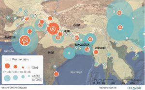
The Indus basin is already one of the worst affected by extreme weather events in the HKH region, with the most people killed from 1980 to 2015. It is also one of the areas where a number of hydropower projects and large dams are either planned, or being built, including key hydropower projects in Pakistan supported by China under the China-Pakistan Economic Corridor project.
Sustained, and even increased, water flow in the rivers until at least 2050 will mean that there will be little rationale to reassess these dam projects if they are based only on narrow economic rationale. The variation of water flows, in fact, will boost those arguing that large storage projects are needed to stabilise water availability over the year. Unfortunately the history of hydropower projects in South Asia – and elsewhere – has been marked by a lack of regard for environmental safeguards. Moreover, in India alone, indigenous communities, accounting for only 8% of the population, have been 40% of those displaced by large dams, primarily because they live in mountainous regions.
See: There is no harvest, how will we celebrate?
Compounding the problem for the Indus basin is the conflictual relationship between the four countries that share it: China, India, Pakistan and Afghanistan. Given the stark threat to the whole basin, and the people that live within it, development plans for the region would ideally incorporate findings for the whole area, as well as coordinating disaster management plans. While people have called for the expansion of the Indus Waters Treaty to deal with these issues, with the treaty itself under strain, there seems to be little scope for such an understanding to develop.
See: Expand the Indus Waters Treaty to make peace
See: The Indus Waters Treaty: caught between a dispute and a hard place
The HIMAP report should act as a warning of a clear and present danger for all those living in the Indus basin, and spur a conversation on key issues of development planning. Unfortunately one of the other issues that the report makes clear is that geographically precise information from mountainous regions remains sparse. This is because the decisions for mountain areas are still largely made by policymakers in the plains. Until and unless that changes, the Indus will continue to be a river of disasters.


![A view of receding flood waters in Srinagar city during the September 2014 flooding. [image: Athar Parvaiz]](https://dialogue.earth/content/uploads/2017/11/A-view-of-receding-flood-waters-in-Srinagar-city-during-the-September-2014-flooding-Credit-Athar-Parvaiz-e1509633052651-300x225.jpg)


![The Brumadinho dam collapse comes just three years after a similar catastrophe in Mariana [image via: WikiCommons]](https://dialogue.earth/content/uploads/2019/02/Brumadinho-and-Mariana-1440x720-300x150.jpg)