![<p>A glacial lake in front of Ama Dablam, a mountain in Nepal [Image by: Zoonar GmbH/Alamy]</p>](https://dialogue.earth/content/uploads/2020/09/glacial-lake-Himalayas-Nepal-Ama-Dablam-300x200.jpg)

New research has found that more glacial lakes in the Himalayas are forming, of which 47 are critically dangerous and could burst, flooding downstream areas in Nepal, China and India.
“Altogether, 3,624 glacial lakes were mapped in the Koshi, Gandaki and Karnali river basins of Nepal, China and India.
“Of these, 1,410 lakes are equal to or larger than 0.02 square kilometres, which are large enough to cause serious damage downstream if they burst.
“However, 47 are the most dangerous ones that need immediate mitigation action,” said Sudan Bikash Maharjan, one of the authors of the report, which was jointly produced by the International Centre of Integrated Mountain Development (ICIMOD) and United Nations Development Programme in Nepal.
Of the 47 lakes, 25 are in the Tibetan Autonomous Region of China, 21 in Nepal and one in India.
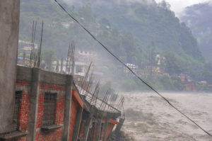
Expanding lakes increase the risks of glacial lake outburst floods (GLOFs) – sudden releases of large quantities of water that wreak havoc on mountain communities. A 2011 study by ICIMOD reported there had been 24 GLOF events in Nepal since the 1980s, 14 of which had occurred in Nepal, while 10 were caused by flood surges across the China‒Nepal border. Such events result in loss of life, houses, livestock and infrastructure, and cause millions of dollars of damage.
Melting glaciers, growing lakes
Several studies have shown that glacier-covered areas in the Himalayas have decreased significantly in the past three decades as temperatures have risen by more than double the global average. If global temperatures rise above 1.5C by 2100, two-thirds of glacier ice in the Himalayas will be lost. As glaciers melt, new lakes have formed and existing ones have expanded.
“Glacial lakes tend to grow in response to higher glacier melt. This can increase the hydrostatic pressure, which can cause structurally weak and unstable dams to breach suddenly. This can result in a sudden, high discharge of debris and water in a few hours, causing catastrophic floods,” said Deepak K.C, a senior climate risk management expert at UNDP Nepal.
A recent study by NASA found that globally the volume of glacier lakes increased by almost 50% between 1990 and 2018.
In the three river basins that form the Ganga river, the total area of glacial lakes has increased from 179 sq km in 2000 to 195 sq km in 2015.
The glacial lakes mapped in the ICIMOD report range from 3,400 to 6,100 metres above sea level in the Himalayas. Above this altitude, landforms are too steep and cold for permanent lakes to form.
The researchers classified the 47 most dangerous lakes into three ranks of risk, based on remote sensing and past studies – though they said it was not possible to rank them precisely.
“Outburst [floods] can occur that have no precedent, especially in view of the current atmospheric warming,” said Samjwal Ratna Bajracharya, another author of the report.
“The [lakes] under rank I have a greater possibility of expansion, are dammed by loose moraine material, and could experience snow and/or ice avalanches and landslides in their surroundings that may impact the lake and the dam. A slight rise in the water levels of these lakes or a reduction in the strength of their dams could cause a breach. The lakes classed under ranks II and III have the potential to grow, and hence need close and regular monitoring,” added Bajracharya.
Of the 47 lakes, 31 are classed as rank I, 12 as rank II and four as rank III.
Koshi – a hotspot for dangerous lakes
The report says the Koshi river basin – a major tributary of the Ganga – is a growing hotspot for dangerous glacial lakes in the Himalayas. Forty two out of the 47 potentially dangerous lakes are in the Koshi basin.
The Koshi basin also has most glacial lakes.
Between 2000 and 2015, the total area of glacial lakes in the Koshi basin increased by 12%, 8% in the Gandaki basin, and 1.27% in the Karnali basin.
The overall number of glacial lakes has decreased in the Koshi basin from 2,119 in 2000 to 2,064 in 2015, as smaller glacier lakes have merged. “But the overall lake area has increased,” added Arun Bhakta Shrestha, another member of the ICIMOD research team.
Read: The Koshi River: a journey down the lifeline of Nepal
Transboundary cooperation a must
More than 50% of the dangerous lakes identified by ICIMOD are in Tibet.
A study published in June by Chinese researchers mapped 654 glacier lakes in the Tibetan Plateau of China. It identified 246 of them as dangerous.
“We not only analysed the characteristics of the lakes, such as coverage area and growth speed, but also considered if there are communities and infrastructure downstream,” said Wang Shijin, an associate researcher at the Chinese Academy of Sciences and one of the authors of the study.
Liu Shiyin, a researcher at the Institute of International Rivers and Eco-security at Yunnan University, said that mitigation measures are already being planned at some high-risk glacier lakes. “This will also reduce the risks for countries downstream,” Liu added.
Experts have urged countries for more cooperation in monitoring glacial lakes and reducing the risks they pose. “We have consulted with some research agencies in China including the Chinese Academy of Sciences with whom we have a good relationship. We are hoping to do more field studies together to validate this information,” said David Molden, director-general of ICIMOD.
Wang said that researchers in upstream and downstream countries should work together to address the problem. “Assessing the outburst risk of high-risk glacier lakes in China, the upstream country of the rivers, could provide scientific analysis for the countries downstream,” he said.
ICIMOD has made efforts to foster more cooperation, but geopolitical tensions in the region have got in the way.
Out of 20 agreements and memorandums of understanding signed between Nepal and China, one is on disaster risk reduction and emergency response. Several high-level meetings between the two countries have taken place in the past few years, but high mountain transboundary research has not been prioritised.
“If those lakes in Tibet burst [water] will eventually flow south to Nepal, devastating communities here [in Nepal]. There needs to be stronger cooperation between the two countries to curb this problem but I don’t see much progress,” said Ngamindra Dahal, chair of Nepal Water Conservation Foundation.
One example in the new ICIMOD report highlights the lack of cooperation and information exchange. It describes past efforts to lower the water level in four rank I lakes in Tibet to reduce the risk of GLOFs. “The water level of Tsho Rolpa in Nepal was lowered by more than 3 metres in 2000, and of Imja Tsho, also in Nepal, by 3.4 metres in 2016. Similarly, the water levels of two lakes in the TAR, China, had also been lowered, but the details are not known.”
At a local level, however, some cooperation has been reported recently. According to local media outlets, in July this year local authorities in Tibet along the Bhotekoshi river warned their counterparts in Nepal’s Sindhupalchowk district of a possible GLOF from Keyrung Tshyo glacial lake in Tibet. This meant that Nepali communities could be alerted.
While there is still little research in high mountain areas, the agencies involved told The Third Pole that the new ICIMOD data will help governments take climate change more seriously and enhance transboundary cooperation. “We believe that this new information will be taken as an opportunity to work together by the governments as it is of critical importance to all countries that share these basins,” said Ayshanie Medagangoda-Labe, resident representative at the United National Development Programme in Nepal.