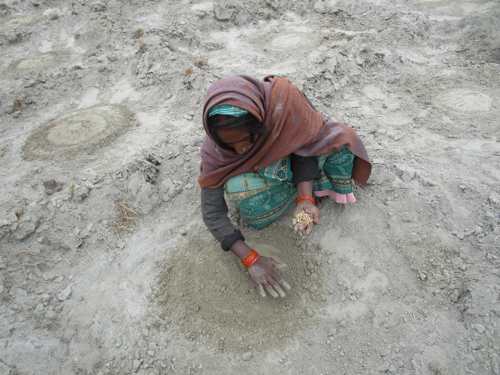
![<p>Landless farmers in Laukariya village of West Champaran, Bihar, practise silt farming in which they grow vegetables on sand deposited by the Gandak river [image by: Nidhi Jamwal]</p>](https://dialogue.earth/content/uploads/2018/10/IMG_3663-300x225.jpg)

Every year, after the festival of Diwali, Pramod Prasad, a landless farmer from Surajpur village in Bairia block of West Champaran in Bihar, packs a set of clothes and some utensils to set out for the Gandak River. He leaves behind his wife and four children, whom he would now meet only after five to six months. Using a dengi (local term for boat), he crosses the Gandak to reach diara, an island inside the vast expanse of the river-spread. On the other side of the river is the neighbouring Indian state of Uttar Pradesh.
On this diara (a piece of land inside a river created due to deposition of sand), Prasad constructs a small, makeshift hut to spend the next five-six months. He is joined by other landless farmers, some from the adjoining district of East Champaran, who also construct their own temporary huts. Thus begins the annual process of silt farming by the landless farmers of Champaran, who mark boundaries on the diara to grow various fruits and vegetables.
“I am practising silt farming for the last 15-20 years now. My father used to do the same. Growing fruits and vegetables on sandy soil requires hard labour. Risks are also high. But the returns are good,” said Prasad, who last year earned a profit of INR 450,000 (USD 6,200) from the watermelon crop on four bigha (one bigha is equal to 0.16 hectare / 1,600 square metres) land of the island.

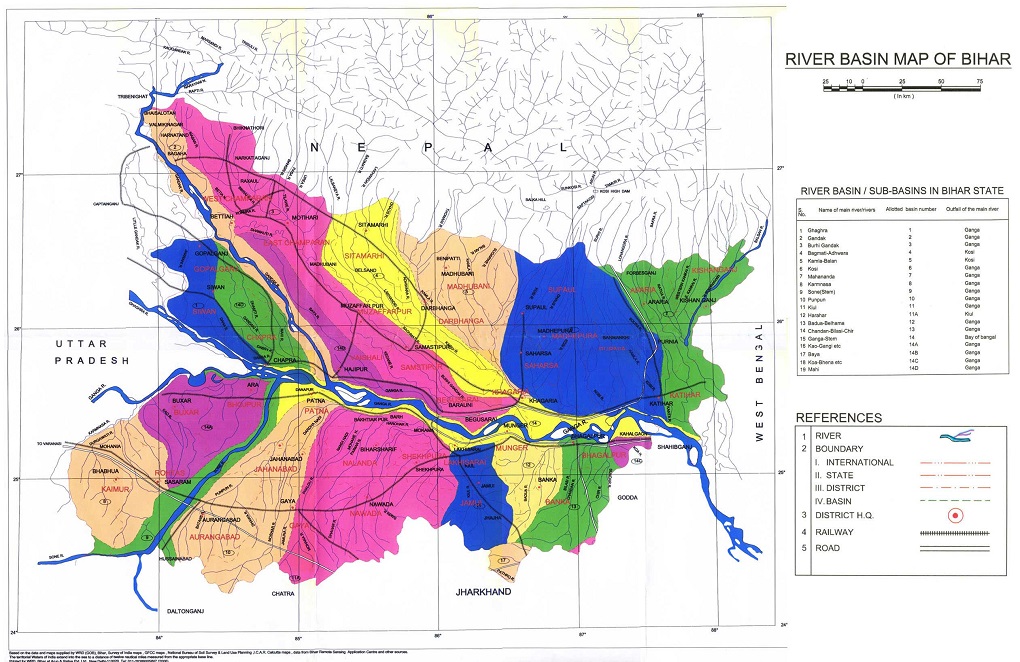
Bihar is India’s most flood-prone state. North Bihar has a number of perennial and non-perennial rivers that originate in the Himalayas in Nepal and carry high sediment load, which they deposit on the plains of Bihar making them one of the most fertile lands in the country. These rivers – Gandak, Burhi Gandak, Kosi, Kamala, Balan, Bagmati, etc – are tributaries of the Ganga (see map 1: River basins in Bihar, India). Majority of the rainfall (990-1,700 mm) in the region is concentrated in three months (July to September) of monsoon when the flow in these rivers increases by 50%, often leading to floods.
As per official records of the state government, 73.63% geographical area of North Bihar is prone to floods. Of the 38 districts of the state, 28 get flooded regularly (of which 15 districts are the worst affected) causing huge loss of property, lives, farmlands and infrastructure. During the infamous 2008 Kosi floods, over 350,000 acres of paddy, 18,000 acres of maize and 240,000 acres of other crops were destroyed, impacting close to 500,000 farmers.
However, floods also play an important role in sustaining agriculture in the region. Almost 81% of Bihar’s population is employed in agriculture, which is much higher than the national average. The rivers carry sediment from the Himalayas and deposit it far and wide on the floodplains. These floodplains are used by local people to grow crops such as paddy, sugarcane, pulses and mustard. Farmers, who do not own land and are very poor, use the sandy banks of the river to cultivate fruits and vegetables.
Agricultural experts claim that agro-productivity in diara areas, cultivated by farmers like Prasad, benefits from the floods as floodwaters not only deposit a layer of clay or sand, but also remove pests.
Silt farming in Gandak river basin
Gandak river, known as Narayani in Nepal, enters India near the Valmiki National Park and Wildlife Sanctuary in West Champaran. It then flows through the plains of Bihar to meet the Ganga river near Patna.
The benefits of silt are well known since ancient times. India’s earliest known civilisation originated on the fertile floodplains of the Indus river where farmers started to cultivate the rich soil left behind by the river floods. Till some decades ago, silt gathered at the bottom of village tanks and lakes was extracted and reapplied on the farmlands to increase soil fertility and crop productivity. But with the adoption of modern agriculture and chemical farming, silt farming has reduced.
However, several poor and landless farmers of West Champaran are still involved in silt farming to eke out a living. Given that there are a large number of landless labourers in the region, and flooding is a common occurrence, this form of farming provides livelihood to many. The Census of India 2011 noted that only 14.71% of the district’s population were cultivators. A whopping 67.45% were agricultural labourers.
As Gandak river keeps shifting its course, it exposes new areas for cultivation. Land records of these areas, especially the diara, are not clear. Hence, landless farmers use such areas for silt farming between the months of December and May.
DIY silt farming
Driving on the east embankment of Gandak river in Nautan block of West Champaran, one reaches Laukariya village. Forty-five-year-old Dhurak Mukhiya is a resident of this village. Mukhiya is landless. To rear his family of a wife and six children, he practices ret ki kheti.
During the rabi season, Mukhiya rents three to four katha land on the banks of Gandak river, adjacent to his village, for six months against a payment of INR 1,000 (USD 14) per katha to the landlord (one katha land equals to 1/20th of a bigha or 67 square metres).
“This sandy land where we are standing right now is covered with Gandak’s water throughout the monsoon months. It is only in December that we begin cultivation and wind up everything before the next monsoon,” says Mukhiya. Fruits and vegetables like cucumber, watermelon, muskmelon, bitter gourd, bottle gourd, and pointed gourd need loose texture soil with good drainage, hence sandy soil is the best, he added.
“In seven to eight days, the seedlings appear. These are covered with dry grass to protect them from birds. A temporary boundary wall is also erected around the cultivated area to avoid cattle straying into it. To protect young plants against low winter temperature and frost, a thatch screen is made using paddy straw,” said Mukhiya who planted muskmelon last season. Farmers prefer fruits and vegetable crops as these are ready in three to four months and provide quick money.
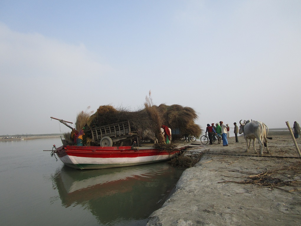
In April and May, once the produce is ready, farmers carry it to the local market. “We are too poor to afford a pickup, so every morning we load the produce on bicycle and take it to the neighbouring market of Jagdishpur or samiti bazaar at Bettiah,” said Mukiya.
High inputs, low returns
Though silt farming provides livelihood to landless farmers, profit margins are very low. “From one katha land, at best I earn about INR 4,000-5,000 (USD 55-69). But, my input costs are over INR 2,000 (USD 28) per katha. So, eventually I earn only INR 2,000 (USD 28) per katha,” lamented Mukhiya.
There are various input costs and risks, which make silt farming difficult for landless farmers. Apart from paying the land rent, farmers spend at least INR 500 (USD 6.90) per katha for manure, urea, and potash which is applied before sowing the seeds. It is reapplied once the plants grow. Labourers are also hired to remove the weeds and grass. Most farmers save seeds for the next season, thereby cutting down on the expenditure of buying new seeds.
Manure and labour cost aside, watering of the crop is an additional input cost. “Watering is needed one or two times. I hire a tubewell machine which costs INR 200 (USD 2.80) per hour,” said Mukhiya, who until five years ago, used to migrate to Punjab to work as a daily wage earner. It was in Punjab that he learnt about silt farming and decided to practise it in his village.
In spite of the hardships, Mukhiya has inspired some fellow landless farmers, such as 60-year-old Nageen Paswan of Laukariya village, to try their hands at silt farming. “Till two to three years ago, I used to work as a daily wage earner. Then I saw Mukhiya growing cucumber on the sandy banks of Gandak. I decided to give silt farming a try. Now, during the rabi season, I, too, grow cucumber or watermelon,” said Paswan, who cultivates four katha land under batai system and shares half his produce with the landlord.
Both Mukhiya and Paswan are extremely critical of hunda and batai systems of cultivation, which they claim make the rich landlords richer at the expense of poor landless farmers. “But, we have little choice… It is the Gandak river that sustains us. Landlords find it difficult to cultivate on sandy lands. We have adapted to ret ki kheti,” said Paswan. He claimed that Gandak has been shifting course and moving eastwards towards Laukariya village. “Some 20-30 years ago, Gandak was two to three kilometres away from our village. Landlords used to grow paddy and wheat on this land. Now, the river is only 500 metres away and it has deposited sand all around. We have learnt to grow vegetables and fruits on the sand,” said Paswan. According to him, the biggest challenge is to protect the crop from cold. Hail is also a major risk to the crops.
Overall, silt farming has several benefits. It brings vacant sandy land under cultivation and provides livelihood to the local landless farmers whose families also get to consume the fruits and vegetables. In case of farmers like Mukhiya, it has also put an end to migration.
The future may lie in diara farming
In spite of the fact that a large number of landless farmers are involved in silt farming in Gandak basin of North Bihar, there is no data on total land under such cultivation and the exact number of these farmers. As per an official estimate, Bihar has 0.9 million hectares of diara lands. Assam’s diara lands may exceed 2.3 million hectares. Odisha has about one million hectares of such lands. A 2012 research paper by Pradeep Kumar Singh titled “Cucurbits Cultivation under Diara-Land” in the Asian Journal of Agriculture and Rural Development claimed that about 65% of total cucurbit (a plant of gourd family including melon, pumpkin, squash and cucumber) cropped area in India falls under diara lands.
The government of India has started showing interest in the agriculture potential of diara lands found extensively in West Bengal, Bihar, Uttar Pradesh, Assam and Odisha. “Flood plains of the eastern India in general and of the diara lands in particular, hold the key to our national food security. It was, therefore, found imperative that data must be collected and compiled on all the existing knowledge base about the flood plain agriculture with reference to its social and environmental dimensions. It is through the analysis of such knowledge-base that methodologies for management of floods and flood plain agriculture, including those of the diara lands can be formulated,” states a document of the Union Ministry of Environment, Forests and Climate Change.
Researchers claim that introduction of appropriate technologies in diara lands has high potential to reduce poverty levels of some of the poorest farmers. “In these areas, awareness of potential technologies is extremely low and mainly very old traditional methods of cultivation are practised. Several extremely promising options exist for these areas that could substantially improve livelihoods of farming families dependent on this land type. Currently there has been little recorded adoption of RCTs [resource-conserving technologies] within diara lands, and there is a clear need to increase efforts to disseminate appropriate technologies into these areas,” recommends a 2004 study published by International Maize and Wheat Improvement Centre.
As of now, though, this silt farming remains the preserve of the poor, with the limited potential that they can invest in new techniques.
Nidhi Jamwal is an independent environment and development journalist based in Mumbai, India. Her Twitter handle is @JamwalNidhi and email is [email protected]
~~
This is the sixth in a special series of reports by women journalists, done in partnership with ICIMOD, showing how vulnerable communities innovate and adapt in the face of climate change.
The Hindu Kush Himalaya (HKH) region is one of the world’s youngest, highest and most fragile mountain systems. It is one of the areas most vulnerable to climate change, where temperatures are rising much faster than the global average. It is also an area of huge cultural diversity – where some of the poorest communities face huge challenges.
The Himalayan Adaptation, Water and Resilience Research (HI-AWARE) is a research consortium that has carried out scientific and participatory research to better understand the impacts of a changing climate in the region. As part of this project, HI-AWARE reached out to women journalists across the region to capture local experiences – from high in the icy mountains to the sandy plains. The stories that emerged are now being published on thethirdpole.net as part of a special series to be published over the next few months.
From farming silt on the banks of the Gandak, to harvesting water through artificial glaciers in the mountains, these stories capture the innovative adaptation strategies people are using and that can serve as lessons for communities elsewhere.

![Bhutan elections 2018. Bhutanese scrutinise claims on an election board - the only place where political parties are allowed to put promotional material [image courtesy: Kuensel]](https://dialogue.earth/content/uploads/2018/10/election-2018-300x225.jpg)
![Farming the biofuel Jatropha in Morocco [Image: Joydeep Gupta]](https://dialogue.earth/content/uploads/2018/10/Jatropha_Morocco-300x225.jpg)
![In a village on the edge of the Sundarbans and facing the Bay of Bengal, Jasimuddin Sarkar in front of his farm that now grows nothing, thanks to sea level rise, and his house that gets flooded with dirty saline water every third or fourth day [image by: Joydeep Gupta]](https://dialogue.earth/content/uploads/2018/10/Farmer_Jasimuddin_Sarkar_Baliara_Mousuni_Joydeep-e1515995272635-300x200.jpg)


