“We have updated the time series, and it appears that groundwater depletion has continued at nearly the same rate since 2009,” said Matthew Rodell, hydrologist at the US space agency’s Goddard Space Flight Center, who used satellite-based measurement of the Earth’s gravity field to revealthe severity of the problem. “There were one or two years when the region got quite a bit of rainfall, but (rainfall) declined after that. So there is natural variability but it averages out over time, and the long term groundwater depletion rate is consistent.”
A second study, also based on data from the Gravity Recovery and Climate Experiment (GRACE), revealed that the most intensively irrigated areas in northern India, eastern Pakistan and parts of Bangladesh have “probably the largest rate of groundwater loss in any comparable-sized region on Earth”. The study by scientists at the CSIR -National Geophysical Research Institute in India’s Hyderabad city, the University of Colorado and the National Center for Atmospheric Research in Boulder indicates that groundwater is depleting at an overall rate of 54 cubic kilometres per year, consistent with Rodell’s results.
“Groundwater depletion in northwest India is a known problem,” according to a story in Nature that accompanied Rodell’s paper, “but Rodell’s data suggest that the loss rate (was) around 20% higher than the Indian authorities (had) previously estimated.”
“We have compiled groundwater level data now and they do show a similar trend,” confirmed Virendra Tiwari, a project leader at the CSIR (Council for Scientific and Industrial Research)-National Geophysical Research Institute. He noted that India’s Central Groundwater Board published an atlas in 2012 documenting the depletion.
Rodell pointed to the free supply of electricity for pumping groundwater in the region as a major cause of the unsustainable depletion. Tiwari said the government of India has taken measures to address the problem. According to The Hindu, “The 12th Five Year Plan clearly calls for ‘more holistic aquifer management strategies’ including separation of electricity feeders for agriculture and domestic use to ‘break the cycle of free use of electricity and excess use of groundwater’.” But it’s not clear if these measures are being enforced or having any impact.
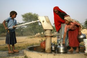
“It is frightening,” said Rodell, “114 million people lived in those states at the time of our study, and many spend much of their day looking for water. There are anecdotal stories of wells dropping by 30 feet in a year. Eventually, you reach a geologic material that doesn’t yield much water, or the water quality becomes too poor for drinking. It’s unsustainable.”
Tiwari has made a couple of policy suggestions, recommending an “assessment of replenishable water storage every year in view of changing climatic pattern(s), which will help in planning of resources, and construction of a large number of small ponds, which were prevalent in India earlier”.
The research technique used by Rodell, Tiwari, and their colleagues, employing data provided by GRACE, holds great promise for evaluating groundwater resources in water-stressed regions around the world. Other studies have since come out measuring groundwater depletion in the Middle East and the north China plain.
GRACE, which comprises two satellites that orbit the earth together 200 kilometres apart, works by measuring variations in the Earth’s gravity field as it disturbs the orbits of satellites, causing the distance between them to change over time. The satellites’ interferometres send microwave beams to each other to measure the distance between them with extreme precision, down to the level of microns.
By recording their precise location and the distance between them, scientists can measure the shape of the Earth’s gravity field, and can see changes from month to month due to changes in the mass of the Earth below. These changes are mainly caused by one of three factors: ocean tides, atmospheric circulation, which can be measured separately and subtracted out of the data, and finally terrestrial water storage, which consists of surface water, snow, ice, soil moisture and groundwater.
“Although its spatial resolution and temporal resolution are low in comparison with those of other Earth-observing satellites, GRACE has the major advantage that it senses water stored at all levels, including groundwater,” Rodell’s paper points out. “Unlike radars and radiometres, it is not limited to measurement of atmospheric and near-surface phenomena.”
In Rajasthan, Punjab and Haryana, the researchers found a net loss of 109 cubic kilometres of water between August 2002 and October 2008 – an amount equivalent to triple the storage capacity of Lake Mead, the largest man-made reservoir in the United States.
NASA subsequently set up a website with graphics and video to explain the GRACE data and research results, and Rodell says he’s working on a new manuscript that will update the situation.