![<p>The Brahmaputra could be India’s access route to Southeast Asia [image by: Chandan Duarah]</p>](https://dialogue.earth/content/uploads/2017/08/Brahmaputra-dredging1-300x225.jpg)
The navigation potential of the Brahmaputra is immense but in desperate need of an overhaul. Cargo vessels are rarely seen and passengers are transported in rickety wooden boats. But developing the Brahmaputra into an international waterway, as envisaged in the National Waterways Act, could give the state of Assam and the rest of India’s northeast an edge. This would make it India’s link to ASEAN nations as the government’s Act East policy comes to the fore.
The Brahmaputra National Waterway 2 – an 890 kilometre-long reach of the river from Sadiya in Assam to the Bangladesh border – could act as the economic corridor to international ports such as Chittagong in Bangladesh and Haldia Port in West Bengal, boosting trade with southeast Asian countries.
To realise such a future, a tripartite agreement for dredging the Brahmaputra was signed between the Assam government on one hand and the Indian inland waterways and national highways authorities on the other at the closing ceremony of the Namami Brahmaputra Festival in Guwahati in April. Nitin Gadkari, India’s union minister of road transport, highways and shipping, hoped that the project would change the economic livelihoods for people in Assam, He announced that the national government would provide 400 billion rupees (USD 6.2 billion) for the construction of the ambitious Brahmaputra Express Highways on both banks of the river.
Deemed one of the largest infrastructure projects in the northeast, the 6.4 billion rupee (USD 998 million) highway will stretch 840 kilometres along both banks of the Brahmaputra between Sadiya and Dhubri. The project was found to be technically feasible by the water resource ministry which, after a preliminary survey, offered to help in the work to stabilise both banks, find sustainable solutions to flooding and erosion, and develop the waterways for navigation. Meanwhile, the World Bank has given 98 million rupees (1.5 million) to the Inland Water Transport infrastructure development project to support its work in dredging the river to maximise its navigational potential and introducing safe, modern and economical passenger vessels and river cruisers for tourists.

The IWT operates 100 ferry services on the Brahmaputra and Barak rivers and their tributaries, used by around 6.9 million people annually. The project of the IWT Directorate for the Brahmaputra — a long term strategic plan, capacity development and improving passenger ferry services — has already started said M Rahman, joint director of the IWT, adding that it would also study the natural flow of the river and the impact of the project on aquatic biodiversity and riparians.
Dredging to control floods?
“Dredging of the Brahmaputra and Barak rivers will not only help to deal with the problem of floods, which affects Assam and Bangladesh, but also improve the navigation facilities in the rivers, which can strengthen trade and commerce between India and its neighbour through riverine routes,” said Sarbananda Sonowal, chief minister of Assam, at the inaugural session of the 8th India-Bangladesh Friendship Dialogue on July 2. According to the chief minister, dredging 1,300 kilometres of the Brahmaputra would also provide material needed to build the highway along its banks, a task for which state government would seek the support and cooperation of Bangladesh.
Dredging the Brahmaputra and its tributaries is not a new idea. “During British rule, dredging was done as a protective measure from floods,” says PK Dutta, an engineer who submitted the dredging plans to Prime Minister Modi. A more recent attempt to dredge the Assam-stretch of the Brahmaputra in 1974 was largely unsuccessful. Dutta’s plan envisages restricting the Brahmaputra within a-two kilometre wide course and using the dredged silt to reclaim the land lost to erosion to build the highways. The current plan remains the same but with one change that the channel to be dredged has been limited to 45 metres. However, no Detailed Project Report (DPR) is available for this project.
Economically not viable
But the project, set to start in September, has been mired in controversy with experts suspecting the dredging is easier said than done. An expert team from the Dredging Corporation of India (DCI) visited Assam in September 2016 and reported that a detailed morphological and hydrological study of the river was needed to explore the possibilities for dredging its huge sediment deposits.

Read more: Reviving the Brahmaputra as the lifeline of travel and trade
“The mighty Brahmaputra and its tributaries carry huge amounts of silt with its flow, around 1.8 billion tonnes per year. Carrying silt from the upper catchment of the Brahmaputra and its tributaries and depositing it in the main stream is a continuous process, mostly due to the vast deforestation and infrastructure development activities in the upper hilly catchment of the rivers,” says Pradip Puzari, a project manager at M/S Patel Engineering Ltd. “It is impossible to make the river bed free from silt deposition by dredging, unless a suitable mechanism is applied to capture and dispose of the silt load flowing into the main stream from its tributaries. Otherwise, the dredged portion of the river bed will be filled up with fresh silt immediately. Dredging along a particular width of a channel along the Brahmaputra for navigational purposes will not support a permanent solution to the recurring floods and erosion of the Brahmaputra basin.”
So where is the need for such an economically-unviable project? Puzari maintains that the state government should come up with a transparent detailed project report (DPR) taking into consideration the riparians and riverine biodiversity.
No environment impact assessment
A highly-active river in an area known for its biological and cultural diversity, the Brahmaputra is the lifeline for communities living along its banks and the fragile ecology of the eastern Himalayan region. The Brahmaputra Valley has been densely populated for centuries and most is still used for agriculture. Some blocks of natural habitat do remain, mainly as national parks and wildlife sanctuaries, including 12 identified as protected areas by the World Wildlife Fund.
“The Brahmaputra and its adjoining floodplain lakes hold hundreds of species of macroinvertebrate and avian fauna, the most fascinating of which is the endangered Ganges dolphin,” says Prof S P Biswas, head of the life sciences department at Dibrugarh University. “Siltation of the river bed and the widening of the river is a common scenario along stretches of the Brahmaputra.The erratic nature of water discharge, high rates of erosion and siltation and habitat destruction have negative impacts on commercial fisheries and native species such as giant catfish, mahseer and turtles. Their numbers are dwindling sharply in the upper stretches, with the Ganges dolphin being the hardest hit.”
Numerous environmental concerns associated with dredging the Brahmaputra need to addressed, but the government seems to ignore those most critical. There are questions over how the construction of the expressways on both banks of the river is possible without disturbing the the river connections with other channels and water bodies. But one key question remains: how can the Assam government continue with such a massive project, without conducting the necessary environment impact assessment?

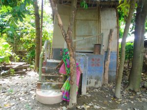
![A woman pumps up water from a tubewell in West Bengal despite the red cross that signifies that there is an unacceptable level of arsenic in the water [image by Dilip Banerjee]](https://dialogue.earth/content/uploads/2017/09/Woman-at-tubewell-West-Bengal-Image-by-Dilip-Banerjee-1-300x206.jpg)
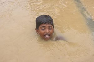
![A flood affected resident of Jakhalabandha, Assam on the south bank of the Brahmaputra being evacuated on a raft on August 13, along with the family's livestock [Image by Biju Boro]](https://dialogue.earth/content/uploads/2017/09/Jakhalabandha-flood-300x200.jpg)