![<p>Devastated irrigation canal in Ghami village, Mustang, Nepal [image courtesy Annapurna Conservation Area Project, National Trust for Nature Conservation]</p>](https://dialogue.earth/content/uploads/2017/01/Devastated-irrgation-canal-in-Nepals-Mustang-distircts-Ghami-village-300x200.jpg)

What happens in the mountains is highly unpredictable, but in recent years an unusual number of major disasters have struck the mountainous regions of Nepal, and the causes are still unknown.
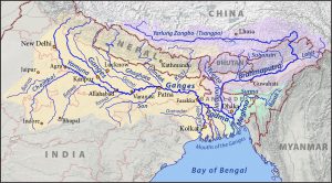
Hills and mountains cover about 85% of Nepal’s territory and the country is highly vulnerable to mountain hazards. Nepal’s northern boundary boasts the world’s tallest mountains including Mount Everest. The region borders China’s Tibetan Autonomous Region (TAR) where Nepal’s major rivers originate and flow down into the Ganga in India.
But when it comes to disasters like floods, the government’s focus is mostly on the southern plains where population density is far greater and the economic damage is high compared to the sparsely populated and rugged mountain regions.
Little has been done to monitor or mitigate disasters in these mountain areas, despite the growing number of strange flood events in recent years. The fact the region’s rivers originate in TAR has made it even more difficult for researchers and officials to find out the cause and prevent future disasters.
Case I: Mustang’s winter flood
December normally brings snow not floods to Nepal, but this wasn’t the case last year for people in Nepal’s Mustang district. While people were preparing for a harsh winter, a sudden flood on the Dhakmar river brought havoc to Ghami village in Upper Mustang — a district bordering Tibet in western Nepal’s Dhaulagiri mountain range. The region falls in the rain shadow area of Annapurna and Dhaulagiri mountains and is known for very low rainfall.
In the floods of 18 December 2016, eight wooden bridges were washed away, houses were damaged, but there were no human casualties thanks to the harsh winter that had forced the majority of the population in the village to move to a lower altitude. “When you look at Google map there isn’t any glacial lake upstream and there wasn’t any rainfall, so it’s hard to say what had exactly triggered the flood in the river. It may be small landslide dam outburst flood or glacial lake outburst flood,” said Basanta Raj Adhikari, assistant professor from the Centre for Disaster Studies at the Institute of Engineering, Tribhuvan University.
He travelled along the river up to its source in 2007 for research and there wasn’t any glacial lake there then. “We have been asking for time series satellite images from our international research partners to analyse and find out the reality but we haven’t received them yet,” he added.
This is the most recent disaster on a list that has puzzled locals as well as the researchers. Officials from the Department of Hydrology and Meteorology (DHM) and researchers have also been left in the dark. Binod Parajuli, a hydrologist at DHM said they have not received satellite images from their partners abroad and are yet to find out why such unusual flood hit the region.
![A broken wooden bridge in Ghami, Mustang [image courtesy Annapurna Conservation Area Project, National Trust for Nature Conservation]](/wp-content/uploads/2017/01/Broken-wooden-bridge-in-Ghami-village-of-Mustand-district-in-western-Nepal.jpg)
On 5 July 2016 there was a massive flood in the Bhotekoshi river, which originates in TAR and forms a major tributary of the Koshi river. Floods are normal on the Himalayan rivers but the scale of flood in Bhotekoshi last year was unusual even though it was during the monsoon. Some experts believe that the flood was due to a landslide dam outburst in Tibet, though this has not been officially confirmed.
A few days after the event, scientists from the Kathmandu based International Centre for Integrated Mountain Development (ICIMOD) claimed that the flood was due to the landslide dam burst, citing research from China, but no further information has been made public.
Case III: Floods without rain on the Seti
On a sunny day in the first week of May in 2012 people were enjoying themselves on the banks of the Seti river, which originates on the slopes of the Annapurna mountain in western Nepal and flows through the Pokhara, Nepal’s most popular tourist city. All of this was swept into disarray as a massive flash flood hit the river. More than 70 people were killed, several villages were swept away, and bridges and schools were destroyed.
See: Nepal’s Seti flood victims still live in fear
Experts proposed several hypotheses of what could have triggered such floods without rain. Some argued heavy rainfall upstream induced a landslide that formed a temporary dam which burst later. Others said rocks and debris brought by an avalanche formed temporary dam across the river and then was hit by another avalanche resulting the burst of the dam causing massive flooding. But arguments over the true cause of the flood continue.
Mountain neglect
According to a 2011 report by ICIMOD, there have been 10 glacial lake outburst floods recorded since 1935 that originated in TAR and affected areas in Nepal. The cause of half of these floods is still unknown. “In addition to geographical complexity, monitoring mountainous areas is highly expensive. Though we have started to work out on some areas like few glacial lakes that are most dangerous (eg: Imja and Tsho Rolpa) in eastern Nepal, a lot needs to be done to cover the country,” said Binod Parajuli.
But experts said the mountains are never the priority of government and there has been little investment in research, even though the country’s tourism is highly dependent on these areas. “Mountains have been neglected because of population driven development that demands more resource allocation to the plains where there are denser settlements,” said Basanta Raj Adhikari, from the Centre for Disaster Studies at Tribhuvan University.
According to the data provided by the DHM, none of the country’s 51 hydrological stations are in the mountain regions, and only 14 of 282 weather stations are located above 3,000 metres. “This is severely insufficient to monitor such complex geography,” added Adhikari.
Nepal has about 3,808 glaciers and 1,466 glacial lakes out of which 21 glacial lakes are dangerous, at a high risk of bursting, says the DHM. Recent research has shown the area covered by glaciers in Nepal has shrunk by 21% over the last 30 years and the rate of glacier melt is increasing. As a result the size of the lakes and the volume of water is growing, putting more pressure on fragile areas and increasing the threat of a lake burst.
According to ICIMOD, the glaciers of the Tibetan plateau are retreating at a faster rate than the glaciers of the rugged central Himalayas. However, there hasn’t been any research specifically linking these puzzling mountain disasters in Nepal to climate change. “We can’t deny the role of climate change but there has to be fair amount of research before we claim [the events were] climate change triggered,” said Adhikari.
[iframe src= “https://earthjournalismnetwork.carto.com/builder/7f76d448-7e37-4a43-b472-bdc4450b8fa2/embed” width=”100%” height=”520″ frameborder=”0″ allowfullscreen=”” webkitallowfullscreen=”” mozallowfullscreen=”” oallowfullscreen=”” msallowfullscreen=””]
Data sharing with China
As Nepal’s major rivers originate in TAR researchers have repeatedly called for a data sharing mechanism between Nepal and China. But since this is a politically sensitive area, there has been little joint research between the two countries.
This is not the only problem, said Adhikari, “There is definitely a trans-boundary component but the major problem is that we have not done what’s possible in our part of the mountains, so blaming others won’t solve our problems,” he explained.
Officials at the DHM said they have not been able to reach a bilateral deal as it has to go through the ministry of foreign affairs, who do not see this as a priority. “We don’t have any mechanism for data sharing with China but recent disasters have shown that we should act urgently,” said Binod Parajuli.
Thousands of tourists flock to the mountains every year for trekking and climbing, which is one of the major economic activities of the country. Since the earthquake in 2015, which killed more than 9,000 people, the risk of mountain disasters has increased, but experts say very little has been done to prepare for the worst.
“Disasters in the mountains will have cascading effects downstream so it is urgent to invest in research and infrastructure to collect continuous data not only on weather but also on slope movements,” Adhikari said.


![[:en]ٹھنڈیانی روڈ، ایبٹ آباد کے قریب پتھر پیسنے کا ایک منظر ( تصویر- محمّد زبیر خان )[:ne]ٹھنڈیانی روڈ، ایبٹ آباد کے قریب پتھر پیسنے کا ایک منظر ( تصویر- محمّد زبیر خان )[:hi]ٹھنڈیانی روڈ، ایبٹ آباد کے قریب پتھر پیسنے کا ایک منظر ( تصویر- محمّد زبیر خان )[:bn]ٹھنڈیانی روڈ، ایبٹ آباد کے قریب پتھر پیسنے کا ایک منظر ( تصویر- محمّد زبیر خان )[:]](https://dialogue.earth/content/uploads/2017/01/Crushers-working-on-Thandiani-road-Abbottabad-300x225.jpg)